Newton Nottingham LLP has led the redevelopment of the former RAF base at Newton. We welcome you to this exhibition of our proposals. The exhibition comprises a series of display boards - each one provides an explanation of a planning application that Newton Nottingham LLP is intending to make soon.
The applications cover a range of proposals. We expect there will be six applications in total.
Members of Newton Nottingham LLP's professional team are present at the exhibition, and will be very pleased to explain more about any of the proposals and answer any queries you may have.
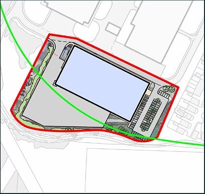
APPLICATION 1
New Access Road
At present, all commercial vehicles travelling to and from the Newton Business Park have to travel through areas of new residential development. This can cause noise and disturbance to local residents. In addition, we are aware of instances of HGVs parking for long periods or overnight, near residential property, while they wait to access the Business Park.
To address these issues, Newton Nottingham LLP proposes to construct a new access road into the Business Park, from Shelford Road. This will achieve a complete separation of access for commercial and residential developments, and will remove all Business Park commercial traffic from the residential areas of the village. At present, we estimate that 5 per cent of vehicle movements on Main Street, and 24 per cent of vehicle movements on Newton Lane, are HGVs; this represents about 150 HGVs per day.
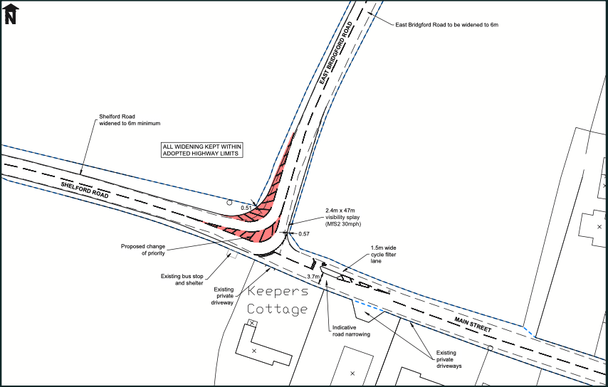
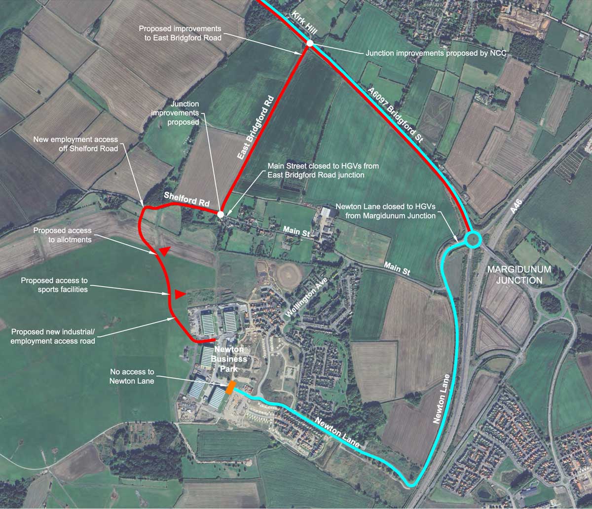
The proposed new road alignment is shown on this plan. When complete, traffic will be able to use the new road to travel between the Business Park and the A46 via East Bridgford Road, the Foothills junction and the A6097. There will be no Business Park traffic passing through residential areas of Newton.
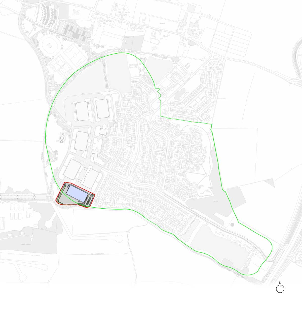
EXISTING
AND PROPOSED
HGV ROUTES
The existing main route for heavy good vehicles (HGVs), the blue route on the plan, is from the Newton Business Park along Newton Lane to the new houses to the A46 and A6097. HGVs also go through the village itself, using Wellington Avenue and Main Street both towards Newton Lane and East Bridgford Road. This is around 150 HGVs a day. Some lorries are parking overnight and in the day time, and cause a nuisance in the local area.
The proposed emerges a new employment access designed specifically for HGVs but also for all other traffic from the existing and new business park. This is from Shelford Road then using East Bridgford Road to the A6097 at Kirk Hill.
The design of the Shelford Road junctions with the employment access and Main Street are designed around encouraging HGVs to use the red route as shown on the plan. This will be reinforced with updated lorry weight restrictions. Shelford Road and East Bridgford Road to the junction with the Kirk Hill would be widened to accommodate HGVs. The connection to Newton Lane would be permanently closed.
The proposed new employment area access would remove HGV traffic from the residential areas served from Main Street, Wellington Avenue and Newton Lane.
APPLICATION 2
New Residential
Development at
Newton Gardens
Land at Newton Lane, at the southeast of Newton village, was granted outline planning permission for commercial development in the original planning permission for the development of the former RAF Newton. Subsequently, detailed planning permission has been granted for some 14,600 square metres (160,000 square feet) of warehouse development on this site.
We are aware that there were objections to this development. Moreover, given its location, its implementation would maintain the issue of potential conflict between commercial traffic and residential areas; it is possible that around 100 HGVs a day could have travelled to and from the site.
Accordingly, it is proposed that this site be used for new residential development instead. The site could accommodate around 110-130 new houses and it is intended that a significant proportion will be 'affordable homes' of different types. This plan shows the area that could be used for residential development.
The scheme proposes pedestrian crossing facilities adjacent to the site access which will provide a link to the residential areas to the north, and improvements to NCR 15 east of the site would allow residents and the wider Newton Village area improved access to the local cycle network.
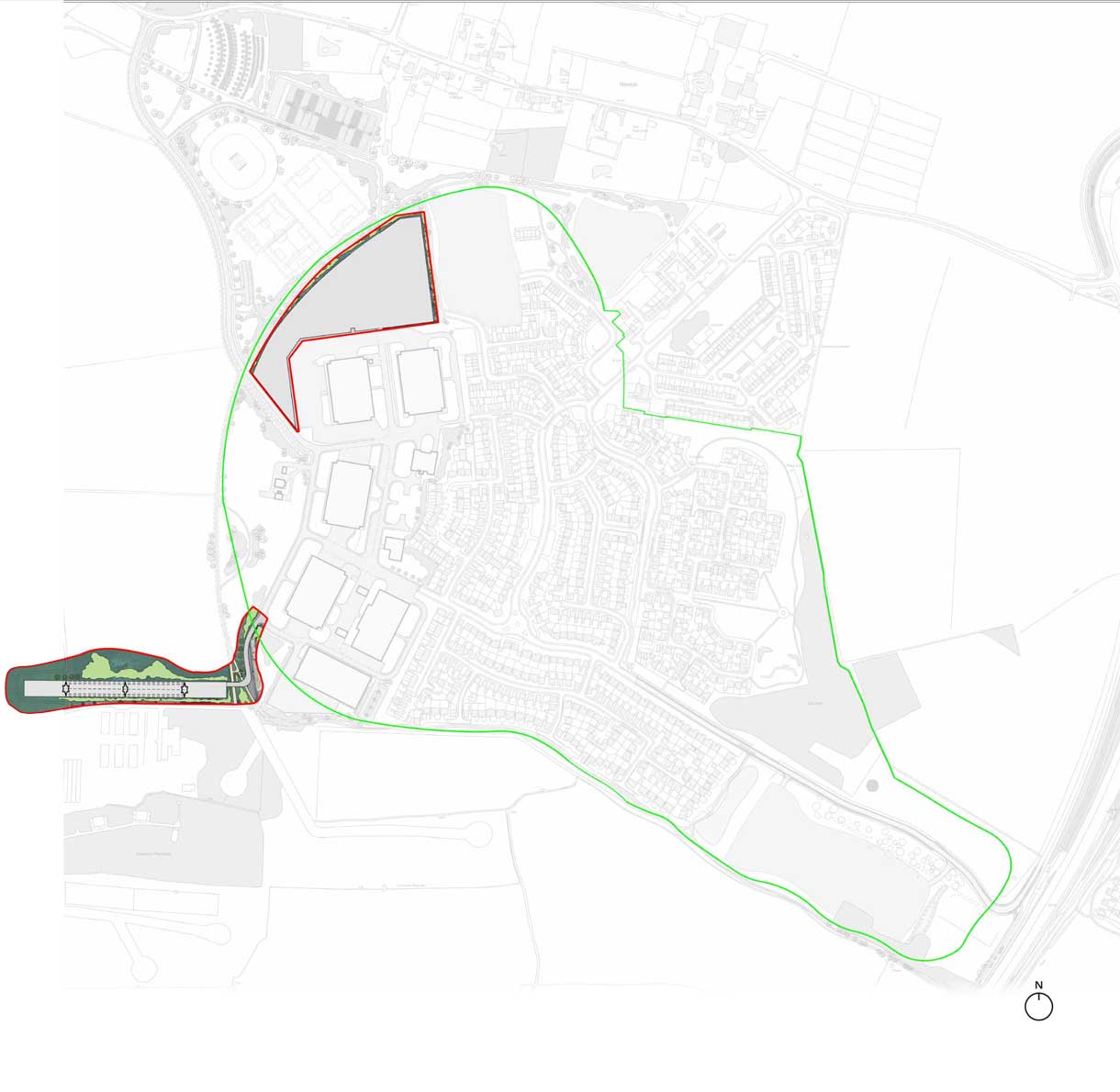
APPLICATION 3
New Employment
Development Within
Business Park
In the previous board, we explained that it is now the intention to provide new housing on land at Newton Lane, in lieu of the consented warehousing development on that land.
However, there is still a need for further employment space at Newton, and strong demand for this type of space from potential occupiers. As a result, it is intended that an application for additional commercial development within the Business Park will be submitted, to replace in part the space that would have been provided at Newton Lane. This development is proposed on land to the south of the existing Hangars, on the site shown on this plan.
The building is intended to provide some 5,800 sq metres (62,500 sq ft) of floorspace and will be 10 metres high, which is of similar height to the adjoining Hangars.
HGV traffic travelling to and from this new building would reach the site via the new access road proposed under Application 1, and would not therefore travel through Newton village.
APPLICATION 4
Removal of Previous
Proposal for A46 Footbridge
The original planning permission for the redevelopment of the Newton site envisaged that a new pedestrian footbridge would be provided to cross the A46. This was to be provided from the southeast corner of Newton Gardens. It is now proposed to amend the original planning permission for Newton to remove reference to the footbridge, and provide instead a package of measures to improve connectivity, accessibility and sustainability of the village.
The bridge will no longer be provided as:
- key funding from Homes in the Communities has been withdrawn by National Highways because of Government spending constraints;
- based on agreed detailed design with National Highways, tender costs for the bridge had become wholly unaffordable;
- there is no evidence of pedestrian safety issues in the absence of a bridge, since the A46 was dualled in 2012;
- practically, Bingham Primary School is too far to walk at 3.5km as the crow flies;
- Newton is in the catchment area of East Bridgford Primary and South Nottingham Academy secondary at Radcliffe on Trent, and the bridge provision is not relevant for travel to these schools.
The package of improvements proposed instead will include:
- improvements to provide footpaths on Main Street and Newton Lane to link to Wellington Avenue and the Newton Lane/Margidunum junction. These are shown on the plan on this board;
- these works would combine with the works for Application 2 and would improve the existing routes to Margidunum, Saxondale and Bingham, for Newton as a whole;
- removal of HGV traffic from local residential roads; and
- potential public transport enhancements;
We expect to secure consent for the works required (for example, for new footways) as part of Application 5, which is described further on the next board.
APPLICATION 5
Relocated Leisure
Facilities, Amendments to
Landscaping, and Footpath
and Cycleway Enhancements
A further planning application is to be submitted to achieve some additional changes to the overall masterplan for the Newton site. These changes include:
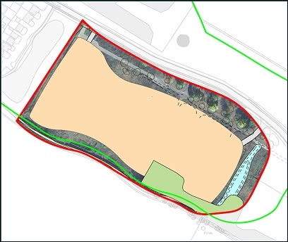
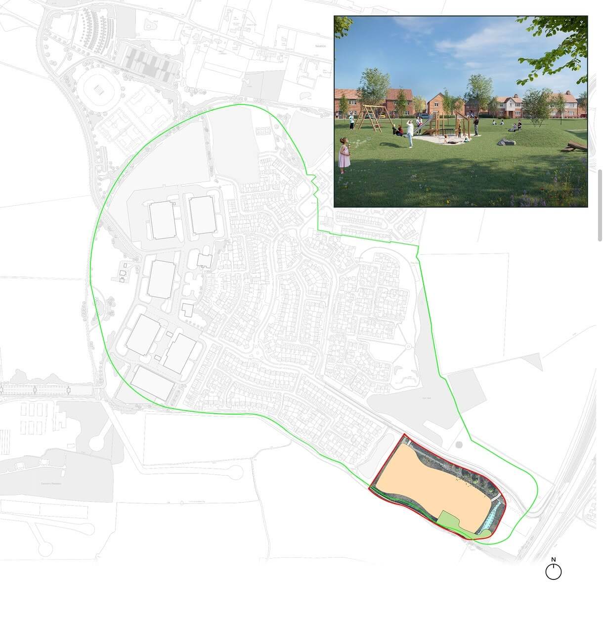
- Relocation of the playing pitches and allotments to land within the line of the new access road. In the medium term, this may allow for some further residential development to take place on land at the north of existing areas of new housing, in overall terms making the most efficient use of land at Newton
- Some changes to the landscaped amenity areas around the edges of the new development, to ensure that provision at a realistic scale, can be delivered, rather than would otherwise be the case, and that future management and maintenance is affordable
- Enhancements to local footpaths and cycleways, as described on the previous board.
These various changes are illustrated on this plan.
APPLICATION 6
Training Facility for
Morrisons Energy Services
In 2024, an application was submitted for a new facility to train workers for the construction and maintenance of high-voltage power line pylons. The facility comprised three 'dummy' pylons and was proposed on land adjacent to the Morrisons Energy Services facility at the Business Park.
The application attracted considerable objection locally, largely on the grounds of the visual impact of the proposals on residential property nearby, and was subsequently withdrawn. However, there remains an important need for a training facility for new workers, whose skills will be of key importance to the national strategic objective of renewing and expanding the National Grid as part of the transition to renewable energy sources.
Accordingly it is now intended to submit a further application for the scheme, but in a new location to the south-west of the Business Park.
This location is much further from residential properties than the previous site, and the existing Hangars and wooded areas to the south of the site will help screen it from view. This plan shows the new location for the proposal. The pylons will be a full 10m lower than the height of the previous proposal.
In addition, Morrisons Energy Services will need to operate a storage area to accommodate equipment and help serve the proposal.
This storage area will be positioned to the north of the existing Hangars, and will be carefully screened by bunding and planting to ensure no adverse visual impact on nearby areas. The proposed storage area is also shown on this plan.
OVERALL
MASTERPLAN
On this board we show, on a single plan, the combined set of proposals that we have described in the previous boards. As well as the six applications, we also show the location of possible medium longer term development to the north of the existing new housing, which may become possible as part of the relocation of playing pitches and recreational uses under Application 5.
You can see how all the proposals fit together, and will provide a series of improvements to Newton as a whole.
KEY
- Residential
- Commercial
- Commercial Hard Standing / Road Ways
- Sports Fields & Amenity